Cheap land | Oil and water
COSTILLA COUNTY, Colo. — Land and water battles have been fought in Costilla County since it was privatized as part of the United States — as evidenced in a number of age-old and contemporary court cases.
When a European investment firm in 1864 purchased he Sangre de Cristo land grant of Mexico, which is now Costilla County, and subdivided the land for new settlers, one overarching problem appeared — the land was already settled. As the grant was converted into subdivisions through a series of mathematic and legal agreements, discrepancies between the previous and incoming systems emerged. These differences were never fully attended to — and still exist. Though every case is unique, each remains rooted in early systems clashes between communal land practices and the birth of real estate.
Once the homeland of the Ute, Diné and Jicarilla Apache, “there was already a community here where the land and the water were being used” when first-wave Spanish, Mexican, Genízaro and Anglo settlers arrived, said Shirley Romero, a San Luis resident whose ancestors were among the land grant’s initial settlers.
“This area has a long history,” she acknowledged.
Dissonance in natural resource management truly raged after the 1848 Treaty of Guadalupe Hidalgo, as then-Mexican citizens gained permission to stay on settled lands during transition to the United States of America.
“They were able to vote — but there was a disparity,” historian and author Virginia Sanchez said of the original settlers. “They were now in an English-speaking territory, with English laws, and new settlers coming in. Newspapers were writing terrible things about the Mexicans — that they'll sell their land for cheap.”
Sanchez’s most recent book, "Pleas and Petitions," outlines Costilla and Conejos Counties' desperate attempts to be annexed back into New Mexico after the area was included as part of Colorado in 1861. The population fought for years to be reunited with their cultural and familial ties to the south, to almost no avail. (Though in 1868, during a re-survey, the original land grant settlement of Costilla, Colorado, was “given back” to New Mexico.)

The abstract of the former Sangre de Cristo Land Grant tells the story of decades of reinvented ownership and efforts to subdivide the once million-acre settlement. Courtesy Edmond Cornelius Van Diest Papers, MS 0233, Box 50, Folder 322, Colorado College Special Collections, Tutt Library.
“This area has seen a lot of power struggles between wealthy land speculators and the original group of settlers that came up here to subsistence farm,” said Joel Nystrom of Colorado Open Lands. “It started in 1864 with William Gilpin, who purchased this land grant — and even then, attempted to remove rights and land from the original settlers and their descendants.”
[Related: Visit a map of regional stories from Costilla County here.]
Though Gilpin served as Colorado’s first territorial governor for only one year, in 1861, it was a front-row education in available prospecting opportunities. His efforts to privately acquire, divide and sell Mexican and Spanish land grants earned him a reputation as a swindler. In 1864, Gilpin and a team of Dutch investors purchased the Sangre de Cristo Land Grant, including the Culebra Mountain sub-range — the reason Costilla County has almost no public lands today. The company then went to work subdividing the land grant into two estates.


An early plat subdividing mining territory in the northern Trinchera Estate. Courtesy Edmond Cornelius Van Diest Papers, MS 0233, Map drawer 5, Colorado College Special Collections, Tutt Library.
An early map of the southern Costilla Estates. Courtesy Edmond Cornelius Van Diest Papers, MS 0233, Map drawer 16, Colorado College Special Collections, Tutt Library.
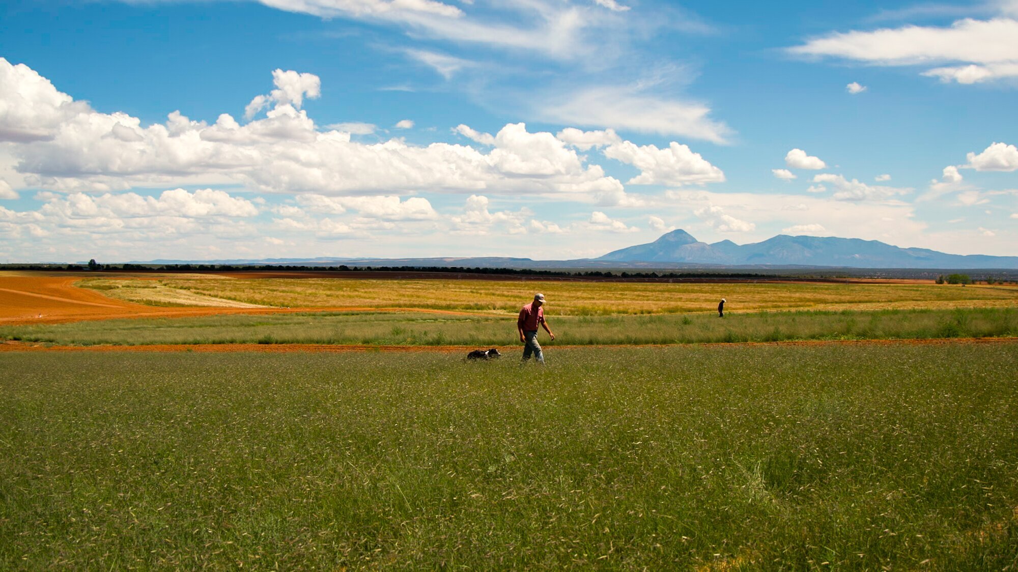
“You just assume Colorado’s highest mountains are public — but the mountains we are looking at right now are private, which astonished me when I learned it,” said author Ted Conover, gazing out at the landscape from within the shade of his backyard shed. Conover’s recent book, "Cheap Land Colorado," follows the county’s contemporary subdivision trends in an arc of continued false marketing and hard times.

Now privately held, the Culebra sub-range of the Sangre de Cristo Mountains has long faced private-public land and water discrepancies.
Conover, who purchased his own subdivided five acres of the former land grant while finishing his book, said he finds the area’s history intriguing. “That the mountains are private, all by itself, is fascinating — and leads you back to the history of where we are," he said.

Author Ted Conover looks over the Sangre de Cristo mountains from inside his shed at home on the prairie subdivisions west of San Luis.
Gilpin and the Freehold Land and Emigration Company “split the ground on the high rise between San Luis and Fort Garland,” said third generation Jaroso farmer Harold Anderson. The division fell mostly across two natural watershed boundaries: the Trinchera Estate to the north, and the Costilla Estate to the south. As Gilpin and Company marketed the estates, their contemporaries warned what false advertising might mean for the future of the west.
[Related: Early marketing has led to a reckoning with Western natural resource consumption]
“William Gilpin tried to make a real estate business out of this, and water,” said Anderson, whose great-grandfather came to the Costilla Estate in the 1910’s in response to the investment firm’s land and water claims. "It didn't work,” Anderson noted of the marketing plan, “though the company did the best they could to keep their investors happy.”


An early map dividing the Trinchera and Costilla Estates. Courtesy Edmond Cornelius Van Diest Papers, MS 0233, Map folder 16, Colorado College Special Collections, Tutt Library.
The Trinchera irrigation district in northern Costilla County.
Communal vs. private land systems
One move aimed at keeping investors happy was the closing off — and sale — of the former land grant commons, on which settlers had been hunting, fishing, grazing and collecting firewood and timber uninterrupted for decades.
Locals immediately protested. They believed they had been promised continued access to the land grant commons through its grantor, Charles Beaubien, and that these rights had transferred when the land was deeded to Gilpin in 1864. Without access to these vital resources, they simply would not be able to survive. Retaliation against the closure of the commons came in many forms, including direct action.
In a typed 1905 letter, Costilla Estate manager Edmond van Diest warns a Denver attorney not to regard Beaubien’s deed for the communal meadows of the former grant east of San Luis, and to deny the rights of settlers to take wood, water, and pasture. “It would be my advice, without qualification, to refuse it. They have absolutely no right whatever to the meadows … [to give them these rights] would be to go to work and give away all the Company’s rights practically … if any of these rights extend to any now, they would be absolutely without control, and for one little right given them they would ask a dozen and trespass in most objectionable manner,” van Diest wrote.

In this 1908 court case, a precursor to Lobato v. Taylor, local shepherds refused to stop grazing their sheep on the former land grant commons and were taken to court by Costilla Estates and their local proxies. Courtesy Colorado College Special Collections, van Diest Papers, MS 0233, Box 50, Folder 322.
Early iterations of what became Lobato v. Taylor emerged in 1908 when local shepherds refused to stop grazing their sheep on the former land grant commons. On behalf of the Costilla Estate, van Diest directed local proxies to sue setters claiming rights. Van Diest’s brother-in-law William Meyer, local merchant A. A. Salazar and his son, Delfino Salazar, filed petitions against several local shepherds to discontinue use of the mountain lands, claiming local landowners had no right to graze as intended by Beaubien. In letters back and forth with the younger Salazar, van Diest’s exasperation grows as local first-wave settlers continually and unceasingly demand water and grazing rights.
In a letter to Estate attorney Albert Smith, van Diest insists settlers’ rights died with the original settlers, and that to try to research title and access for property holders laying claim to the commons as promised by Beaubien would be “so difficult to trace that an abstract or title would be utterly impossible.”
Yet that is exactly what the Colorado Supreme Court ordered 100 years later when they determined aspects of Beaubien’s deed still held. The Beaubien document became a hat stand for community rights in 2002’s Lobato v. Taylor decision to allow local landowners to regain some access rights to the now-private former commons, including grazing of livestock and collection of timber and firewood.
1908 wasn’t the first grazing dispute — and 2023 won't be the last. To this day, management of the commons remains a heated and weighted issue between community members and private landholders. The case remains in legal negotiations, fueled at least in part by a gross miscalculation of the will of the people.
Can a Colorado Supreme Court-recognized Mexican land law be further decided within the courts? Most recently, a judge doubled down on these access rights — then called for a special legal liaison to serve as a problem-solver between mountain rights-holders and the private Cielo Vista Ranch in current and future discrepancies.
“Any time a government takes over from another government and tries to honor the previous government’s conditions, there's two totally different thought processes there that that could work — but that more than likely won’t,” Anderson reflected.

Farmer and rancher Harold Anderson outside his family’s grain elevator in Jaroso, Colorado.
The destiny of this culture clash is a thorn in the side of every interest who has purchased the vast mountain property since.
“I think things are currently working in the descendants’ favor,” Nystrom said of locals who still claim their mountain rights for grazing and firewood. “But they have to be very vigilant to make sure that always stays true.”
This vigilance has been well-documented for over a century — and is only the beginning.
Vara v. PLSS land systems
The privatization of the commons happened in tandem with other systems shifts. In order to quantify lands for settlement, surveyors turned to the PLSS (Public Land Survey System) land grid — a method of establishing Township-Range-Section. They superimposed PLSS values over the traditional Spanish and Mexican land system, creating blips and confusion in ownership that are still contested today.


Early maps drafted by Costilla Estates Manager Edmond van Diest show efforts to place a PLSS land system over top of the pre-existing vara and extenciones systems. Courtesy Edmond Cornelius Van Diest Papers, MS 0233, Map folder 16, Colorado College Special Collections, Tutt Library.
“This land was settled in the Spanish tradition of dividing land into long vara strips, also called long lots, or extenciones, as part of the settlement pattern, instead of using the PLSS,” explained Nystrom. “Vara lots were drawn perpendicular to a stream. They would extend miles in both directions to include not just the lowland areas, but further into the foothills so other types of terrain and ecosystems would be included, all in a long strip. They allowed equal physical access to the water source — it's one of a kind."
[Related: Watch a presentation about Culebra Watershed history by Joel Nystrom of Colorado Open Lands]
But vara strips went on seemingly forever, some for miles, stretching from the mountains of the east to the mesas of the south and severely limiting potential sales. Costilla Estates carved out new land measurements over top of the lengthy varas, creating odd-shaped parcels of land that fell into neither system.
In the 2022 Costilla County court case Cielo Vista Ranch v. Mondragon, both vara boundary discrepancies and property destruction were addressed when a judge decided in favor of Cielo Vista Ranch, the private hiking, hunting, and fishing operation that exists on a portion of the former land grant.
The case presented that while visiting his late father’s vara southeast of San Luis in a foothills agricultural area, Anthony Mondragon arrived to see a ten-foot-tall fence construed by Cielo Vista Ranch. Mondragon testified that he had always known this fenced land to be his family’s. The contested area of 1.4 acres was part of his father’s extencione. A non-irrigated foot hill, the area was typically used as an intermittent pasture between the ranch and common grazing lands.
San Luis has a complicated relationship with fences. It was a property fence that fueled the 1960’s range war resulting in Lobato v. Taylor, when a former owner first fenced locals from the mountains. When Mondragon saw the property fence on what he believed to be his family’s property, he and two friends worked with machinery to dismantle it and tear it down.
Central to this case were surveillance images of the fence removal taken by the ranch’s security cameras — and the initial Costilla Estate maps and documents of Edmond van Diest, circa 1896. But there was little acknowledgment of the traditional land system upon which the original discrepancy derived. Van Diest’s own defining boundary point of extenciones was entered as evidence. In the eyes of the then-Estate, the meandering midway point between Vallejos and San Francisco Creeks was considered the cutoff to the extenciones.
Though van Diest’s pen touched every land parcel in the county, his feet did not; and the extenciones had been long contested in court, for more than a century. Admittedly, the land boundary might follow neither vara nor PLSS. But without further survey, the judge ruled in favor of the ranch.

Portions of maps show detailed ongoing arguments between the Costilla Estate and local landowners regarding the property boundaries of their extenciones from the 1800s on. Differences in PLSS and vara land systems resulted in property battles still ongoing today. Courtesy Edmond Cornelius Van Diest Papers, MS 0233, Map folders 12 and 16, Colorado College Special Collections, Tutt Library.
A half-dozen map folders and collection of boxes spanning van Diest’s time as land and mineral manager of Costilla County reveal a driving commercial interest repeatedly thwarted by local efforts of resistance. The extenciones boundaries were a thorn in his side, as told though a series of maps, charts and tallies. In letters, van Diest highlights problems the PLSS overlay is creating — especially ownership of mountain and mesa extenciones lands, grazing and squatting squabbles. Like today, the estate was in almost constant, one-off negotiations with local landowners, unable to compromise an overall solution.
Edmond C. van Diest
Edmond van Diest was just 19 when he signed on to manage the Costilla Estate in 1884. The son of a Colorado School of Mines metallurgist and a School of Mines graduate, he learned on his family’s associations with the Dutch investors underwriting the land company. Upon arrival, van Diest was charged with all tasks ripe for planning the agricultural townships, mines, rail roads and industry his partners had drafted. Van Diest would live in San Luis for 20 years, until 1904, in an effort to leverage the investment firm’s resources to settle the Estates and fulfill those plans. His records show a community overtaken by paper — titles, deeds, tax rolls, treaties, and court cases. Continuity of the landscape was not priority — obtaining and selling parcels of land, was.
In 1890, at 25, van Diest married Louise Meyer, daughter of prominent wool and sheep trader and merchant Ferdinand Meyer, who went on to play a prominent role in the founding of San Luis and in the relationship between the first and second-wave settlers. The families lived in San Acacio, Colorado and in Costilla, New Mexico in an area called Meadow Farms for more than a decade after and engaged in nearly every possible enterprise while entertaining a series of eastern visitors for whom the rugged West was novel.

Van Diest emigrated from what is now Indonesia at the age of 7. His father and three paternal generations before that served as imperial ambassadors of the Hague in what is now Indonesia. Van Diest attended Denver High School before going on to manage the former Sangre de Cristo land grant. This is his senior photo, courtesy Denver Public Library’s Western History Collection.
The original settlers had been an important head count necessary for Colorado to become a state. Moreover, their labor was integral in the equation of mining, railroads and farmlands. On the other hand, many of them owned the best farmlands and settled favorable, riparian areas. Van Diest's files illuminate each tract taken or purchased back by his company in a peace-meal attempt to reconstruct the Estate’s holdings — minus many of its first settlers.


Van Diest refers to local landowners as “squatters” and seeks assistance in identifying land claims for the estate. Courtesy Colorado College Special Collections, van Diest Papers, MS 0233, Box 61, Folder 396 and Box 50, Folders 324 and 328.
Van Diest was later General William Jackson Palmer’s engineering consultant and assistant, supporting expansion of the railroad and Colorado Springs estates. But he began here, in Costilla County, as a nascent mineral surveyor and prospector, estate seller, bill collector and mine manager, quantifying and calculating each resource with an algorithm known to few.
Van Diest himself later admitted his systems never quite meshed. In a letter responding to a Department of the Interior inquiry about the legality of his mining operations in 1919, van Diest explains, as an aside, that he did not calibrate his PLSS configurations to a clear national standard. He explains to the Interior that he converted the varas into a PLSS grid, and that “It should be stated in this connection that the sub-division survey of the lands of this grant was not made in full accordance with the sub-division of lands surrounding the grant.”
In his later years, writing from Colorado Springs, van Diest is still trying to nail down his future, writing — not typing — that he is “broke, as the expression goes,” and looking for work. His list of business is a bit toppling: national activity in mining and real estate, subdivisions, developments and agricultural settlements, landscape architect, park and green lands design, electric company manager, want-to-be-inventor. Still, van Diest is perhaps best remembered as the individual responsible for the large bronze Palmer statue in the middle of Tejon Street in downtown Colorado Springs.

Sanchez Reservoir southeast of San Luis. The reservoir was an undertaking of the of the Costilla Estates in the early 1900s to bring water west to increase agricultural lands.
Communal v. Shares
“The land system definitely changed – and so did the acequia system,” said Sanchez.
Dug beginning in the mid-1800s, the acequia water system is a community resource maintained by its users. Landowners each have one vote in operations, regardless of how much land they farm. Nobody “owns” the water; it is for the benefit of the community. There are annual cleaning dates, meetings and a community coffer for improvements and repairs.
The New World and van Diest’s imagination brought reservoirs, canals, water companies, ownership, shares — and even different units of measuring the water.
“The new government eventually determined a superseding system of water quantification and measurement that was allocated based on a prior appropriation doctrine — ‘first in right, right in time,’” Nystrom said. “Because these early settlers of had record of creating the first adjudicated water rights in the area, long before statehood, the new government determined their water rights as the first in the state.”
The first water adjudication in the state (the San Luis People’s Ditch, 1852) did not occur until 1889. Between those dates, many more residents would come to call the area home — particularly in the post-Mexico, pre-U.S.A. period from 1848 to 1876. To van Diest, who arrived in 1884, these settlers were unequivocally “squatters” — and they were of particular importance. If potential generations of people had arrived post-privatization and claimed rights to the resources of the common lands, it would vastly deteriorate pastures and forest resources — the same supply on which the new subdivisions now relied.
Further, if those settlers had dug acequias and were irrigating, water resources could skew. The settler’s claims could put the Company in jeopardy.
“We get very little rainwater here because we are in a high alpine valley. So, the water in our acequias is, like we've heard a million times — the lifeblood of this community,” San Luis resident and land rights activist Shirley Romero said. “The bottom line here is water.”

The San Luis People’s Ditch diversion on the Vega Commons in San Luis.
With finite surface rights from mountain snow, developers realized they now had few options to irrigate the land they were trying to sell. What’s more, to expand the estates to the west, they would need to develop a storage and delivery system. In order to obtain water for these estates, van Diest and his proxies engaged in a stringent campaign to loosen acequia water rights from locals, including claiming half of their previously adjudicated rights.
“Van Diest was trying to justify getting water into Sanchez Reservoir from the smaller tributaries of Culebra creek,” Anderson explained.
Van Diest drafted documents over time explaining why original settlers were to give up half their water rights. The agreement between Costilla Estate and the community was signed by a Committee for the People consisting of van Diest's brother-in-law and local business partners. Courtesy Colorado College Special Collections, van Diest Papers, Box 50, folders 326, 328, and 329.
“They filed on about half of the first water rights, claiming that the original settlers had been given too much water — which may or may not have been the case,” said Tom Stewart, who now is charged with administering these complex rights as Water Commissioner for District 24.
Today, many acequia lands are still maintained with traditional farming practices — and many locals still bitterly scorn what they consider to be their stolen half amount of water. However near or far from the original discrepancy, every generation has passed the torch of fighting to legally regain and sustain these water rights.
“The earliest lawsuit Freehold Land and Development company ever had was versus the local natives that were using the water a long time before they ever showed up,” Anderson said. “That was fought in the courts from about 1920 until — the last one was three years ago, I think.”

Anderson explains water rights in Jaroso.
Anderson’s family came to Jaroso as part of a Seventh Day Adventist settlement in the early 1900s during the Costilla Estates’ ever-evolving marketing plan. He said these original discrepancies in land and water systems cast a shadow on the watershed today. “A whole lot of the hassles from Freehold, Costilla Estates, and land and water rights today, are probably tied back to that,” he mused.
“It was settled,” Anderson shrugged. “That water was supposed to go in the Sanchez Reservoir. It was cut and dried. In the law. The judge signed off on it. But there's always questions.”
“They were supposed to have meetings, get together and come up with a method to administer those Freehold water rights,” Stewart said. “It wasn’t followed through with and was left in limbo. The state engineer issued a letter that said, ‘You guys have not carried through, and we will direct the water commissioner to administer this way.’ And that's where I'm at today,” Stewart said. “It is awfully complicated.”
“Awfully complicated” is a phrase that could be used to describe most land and water cases throughout Costilla County. As these early arguments carry on, intensified by scarcity and drought, one wonders what might be in the middle of the Venn diagram between the New World and the Old.
This article is part of a series. “Colorado Voices: Cheap Land Part One” premiers on Rocky Mountain PBS and our YouTube Thursday, Feb. 9 at 7 p.m. “Cheap Land Part Two” airs Feb. 16 at 7 p.m.
Kate Perdoni is a senior regional producer with Rocky Mountain PBS and can be reached at kateperdoni@rmpbs.org.
An abstract title of the Sangre de Cristo Land Grant being entered into the United States of America as recorded by Edmond van Diest in 1884 when he became manager of the Costilla Estates. The land was first deeded to Charles Beaubien, the holder of the Mexican Land Grant. Beaubien passed away mid-deal, and his heirs sold the grant to William Gilpin and his associates. Courtesy Edmond Cornelius Van Diest Papers, MS 0233, Box 50, Folder 323, Colorado College Special Collections, Tutt Library.